Back to Blog

Blog

What is NTRIP?

Devon Sharp
Devon Sharp
Product Marketing Specialist
What is NTRIP

Network Transport of RTCM via Internet Protocol (NTRIP) is a cutting-edge technology that has transformed the way GNSS (Global Navigation Satellite System) correction data is delivered. Originally developed by the Radio Technical Commission for Maritime Services (RTCM), NTRIP acts as a standardized protocol for transferring GNSS correction data over the Internet, allowing for real-time, high-precision location information. Our own GNSS correction service, Skylark, uses NTRIP to deliver real-time centimeter-level positioning data to your device in a matter of seconds.

This system is crucial for industries such as precision agriculture, construction, land surveying, and autonomous vehicle navigation, where centimeter-level accuracy is essential for optimal performance and efficiency.

RTK corrections enhance GNSS data to provide exceptional accuracy. Standard GNSS systems, like GPS, offer location data that is accurate within meters. However, factors such as atmospheric disturbances, satellite orbit variations, and clock errors can reduce this accuracy. Read our GNSS primer to learn more about RTK and other GNSS correction methods.

In this article we’ll explore various aspects of NTRIP including: the underlying technology, its evolution over time, common applications, and how to connect to a NTRIP service.

What is NTRIP?

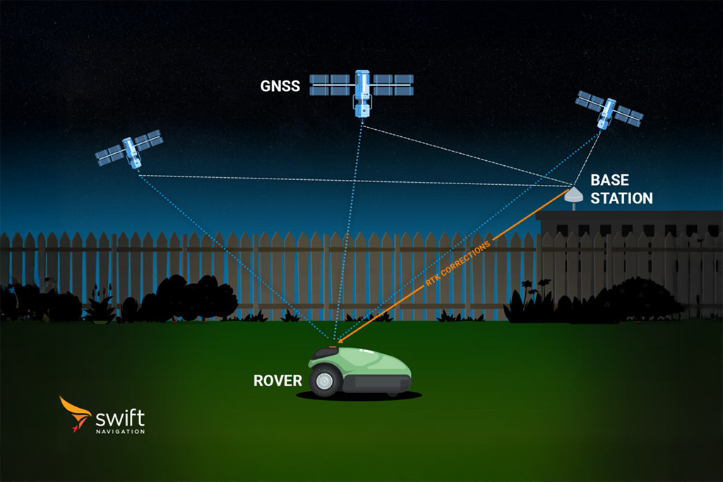
NTRIP enables the transmission of Differential GNSS (DGNSS) and Real-Time Kinematic (RTK) correction data from a base station to a receiver (often called a rover). It acts as a data stream, delivering these correction signals which are critical for achieving highly precise positioning.

How Does NTRIP Work?

NTRIP facilitates the communication of correction data needed by RTK systems by connecting stationary base stations and mobile GNSS receivers via the internet. This creates a pathway for correction signals to travel efficiently from base stations, which have fixed and known coordinates, to rovers. Here’s how it works:

1. Data Collection: Base stations, which are strategically placed and have precise known coordinates, observe and collect raw signals from GNSS constellations like GPS, Galileo, and BeiDou. 

2. Processing: In Traditional RTK, local base stations use these observations to compute corrections. In the case of a cloud based system, such as Skylark, stations do not compute corrections themselves, they transmit raw observations to the cloud which performs the computation.

3. NTRIP Transmission: A central server called NTRIP caster streams the corrections from base stations to the receiver through the internet. This ensures that correction data is delivered quickly and reliably, enabling real-time, high-accuracy geolocation.

4. GNSS Receiver Correction: The rover uses the data to correct its position.

By eliminating the need to manage remote connections to each base station, NTRIP offers a cost-effective and convenient solution for delivering real-time GNSS correction data. Companies looking to implement the highest level of precision in their location-based systems should carefully evaluate their NTRIP service provider to ensure the best possible results.

The Evolution of NTRIP

First introduced in 2004 by the Radio Technical Commission for Maritime Services, NTRIP emerged in response to the growing demand for real-time, high-precision geolocation data. Before NTRIP, correction data was often sent via radio signals, which had limited range and were prone to interference. NTRIP revolutionized the process by leveraging the internet for data transmission, resulting in a more reliable and widespread system.

RTCM defines the format for GNSS correction data, while NTRIP is the protocol that delivers this data over the internet. In essence, RTCM refers to the content, while NTRIP concerns how that content is transmitted.

Since its inception, NTRIP has undergone several updates to improve its compatibility with GNSS systems and enhance functionality. Today, it is the industry standard for real-time GNSS correction and is used across a range of sectors.

How do I Connect to a NTRIP Service?

The general process to connect to a NTRIP service is as follows:

1. Obtain NTRIP credentials from a service provider or local base station. You will need: Username/Password and a Caster URL, which is of the form http://[host]:[port]/[mountpoint]

2. Next, you will require an NTRIP client, most GNSS receivers will have this. The client can take the form of an app if the receiver has bluetooth, or a utility software which can be accessed via serial or USB

To connect to the Skylark NTRIP server, you’ll need to:

1. Sign up to Skylark and purchase a subscription.

2. In the Skylark Portal, add a device to generate a set of NTRIP credentials.


3. Choose your NTRIP username, e.g. 'receiver'.


4. Click ‘View’ to see your NTRIP credentials.


5. Choose the appropriate region (North America, Europe, or Asia Pacific), frequency bands supported by your receiver (L1/L2 or L1/L5, and mount point (RTK-MSM5).

6. Input these credentials into your GNSS receiver’s NTRIP client interface. Pictured below is the NTRIP configuration in the Bad Elf Flex app.


7. Establish the connection and begin receiving GNSS corrections.

NTRIP has truly revolutionized geolocation by providing a reliable, internet-based solution for delivering GNSS corrections, enabling real-time positioning with unmatched accuracy. For industries that require precise location data, understanding and utilizing NTRIP is key to enhancing operations and ensuring optimal performance. While NTRIP remains the gold standard for GNSS correction delivery, emerging technologies like MQTT (Message Queuing Telemetry Transport) are gaining traction, offering lightweight and flexible alternatives for real-time precision positioning in evolving applications.

Read our articles on how to set up the Bad Elf Flex Mini and Emlid Reach RX with RTK corrections for a more detailed overview on connecting your hardware to a NTRIP client.

Unlock centimeter-level precision—contact us or sign up to Skylark to start leveraging GNSS corrections for your application today